Weaver news
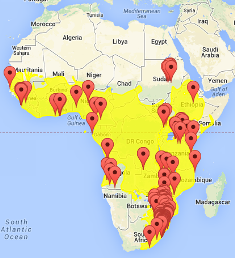
| Yellow areas show distribution of the species (based mainly on Birds of Africa and Handbook of Birds of the World, Vol. 15); maps now available for all weavers; for species with small ranges you need to zoom in at the correct area to see the range. You can zoom in on the map, but note that range edges at highly zoomed levels may be very inaccurate. Maps of weaver ranges will be improved in time, but feel free to email errors or corrections. These maps also show the PHOWN records for that species, so that errors of the PHOWN location and/or range of the weaver can be found. As the maps are fine-tuned, range expansions will become apparent instantly. Generally natural current ranges are shown; in time ranges of introductions will be included. You can switch off the yellow distribution area if you want to see more google earth detail. You can also toggle the Map view/Satellite imagery in the top right corner of the map. As you zoom in and out, there may be a delay in the yellow area being displayed. You can go to the Weaver Wednesday species accounts for notes on distribution and most species show the distribution of currently recognised subspecies in different colours on a ststic map. Maps were produced in Google Earth by Linah Maqashu and Abongile Ndzungu, while interns at the Animal Demography Unit in the DST-NRF Internship Programme 2012/13. |
